MS Vicksburg 1863 MAP – Antique Wall Map

(Each image is professionally and digitally cleaned of artifacts such as color bars and extra borders prior to printing.)
Description
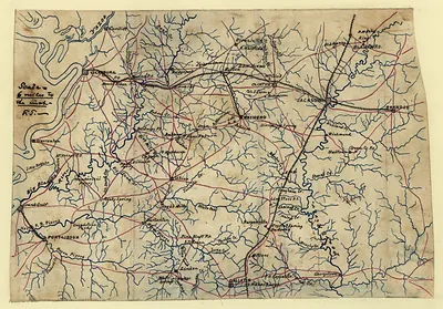
This antique map of MS Vicksburg 1863 MAP brings a moment of history to your wall. It is part of the Snapshots of the Past archive, gathered over 25 years of research.
Choose the framed print, ready to hang the day it arrives, or the unframed print for a frame of your own. Perfect for a home, office, library or classroom wall, and a gift with a story behind it. Free shipping in the lower 48 states. Snapshots of the Past, founded in 2001, has served tens of thousands of customers worldwide.
MS Vicksburg 1863 MAP
Order a print
Thank you. Your order went through, and a receipt is on its way by email.
Secure checkout · SSL encryptedPowered by Stripe and PayPal
Free shipping in the lower 48 states. The checkout page shows the picture, size and price before you pay.
Vicksburg, Mississippi, sits on high bluffs above a sharp bend of the Mississippi River, and that position made it the center of one of the Civil War's decisive campaigns. Union forces under Ulysses S. Grant besieged the town from May into July 1863, and its Confederate garrison surrendered on July 4, giving the Union control of the river. Military maps of the period like this one were used to plot approaches, earthworks and river defenses. Worth noticing is how closely such sheets follow the bends and bluffs that shaped the fighting.
| Created / published | 1863 |
|---|---|
| Original scan | 3,000 × 2,331 px · prints to 10 × 8 in at 300 dpi |
| Reference | MS-Vicksburg-1863 |
More from the Natchez Trace Parkway collection
Snapshots of the Past helps heritage brands, museums, historians and storytellers tell stories with history: historic prints, image licensing and historical storytelling drawn from more than 25 years of research and curation.