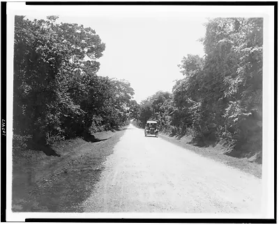
La carretera de Viñales cerca de San Cayetano--Road near kilometer 48 – Historic Reproduction

(Originally scanned by the Library of Congress. Each image is professionally and digitally cleaned of artifacts such as color bars and extra borders prior to printing.)
Description
La carretera de Viñales cerca de San Cayetano--Road near kilometer 48 comes to life in this historic photograph, reproduced from the original with every detail intact. Sourced directly from the Library of Congress, it represents an authentic piece of documented history.
Framed, it is ready for the wall; unframed, it is ready for the frame you choose. A conversation-starting piece for home, office, or as a meaningful gift. Free shipping in the lower 48 states. Snapshots of the Past, founded in 2001, has served tens of thousands of customers worldwide.
La carretera de Viñales cerca de San Cayetano--Road near kilometer 48
Order a print
Thank you. Your order went through, and a receipt is on its way by email.
Secure checkout · SSL encryptedPowered by Stripe and PayPal
Free shipping in the lower 48 states. The checkout page shows the picture, size and price before you pay.
Along a dirt road in Cuba's Pinar del Río province, this view heads toward Viñales, with the marker reading kilometer 48 near San Cayetano. The thatched roofs along the route show the modest rural buildings of the countryside, where small farms and tobacco growing shaped daily life. Pinar del Río, at the western tip of the island, was a major tobacco-producing region, and the Viñales valley is known for its dramatic limestone hills. Roads like this one were part of the slow effort to connect rural districts with towns and markets in the years after Cuba became a republic in 1902.
| Created / published | [1908] |
|---|---|
| Medium | 1 photographic print. |
| Genre | Photographic prints 1900-1910. |
| Notes | No. 61. A. No. AGO. 22-08. |
| Subjects | Roads--Cuba--Pinar del Río (Province)--1900-1910. Thatched roofs--Cuba--Pinar del Río (Province)--1900-1910. |
| Source | Library of Congress, Prints and Photographs Division |
| Original scan | 4,096 × 3,272 px · prints to 14 × 11 in at 300 dpi |
| Reference | AMZ-SOTP-HPA-194591 |
More from the Historic Print Archive collection
Snapshots of the Past helps heritage brands, museums, historians and storytellers tell stories with history: historic prints, image licensing and historical storytelling drawn from more than 25 years of research and curation.