CANADA-Ottawa-1895 – Vintage Map Wall Art

(Originally scanned by the Library of Congress. Each image is professionally and digitally cleaned of artifacts such as color bars and extra borders prior to printing.)
Description
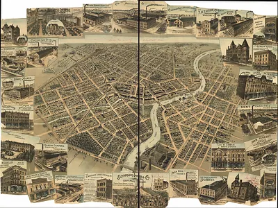
This antique map of CANADA-Ottawa-1895 brings a moment of history to your wall. It comes from the collections of the Library of Congress, scanned from the original and carefully restored.
Library of Congress record: City of Ottawa, Canada with views of principal business buildings
Order it framed and ready to hang, or unframed to match a frame you already love. Perfect for a home, office, library or classroom wall, and a gift with a story behind it. Free shipping in the lower 48 states. Snapshots of the Past, founded in 2001, has served tens of thousands of customers worldwide.
CANADA-Ottawa-1895
Order a print
Thank you. Your order went through, and a receipt is on its way by email.
Secure checkout · SSL encryptedPowered by Stripe and PayPal
Free shipping in the lower 48 states. The checkout page shows the picture, size and price before you pay.
Ottawa, Ontario, in 1895 was a lumber town that had recently become the seat of the Canadian government. Queen Victoria chose it as capital in 1857, and Parliament Hill's Gothic Revival buildings had stood above the Ottawa River since the 1860s. Sawmills and timber booms along the river and the Chaudière Falls drove the local economy, and lumber fortunes such as J. R. Booth's shaped the city's growth. Across the water, Gatineau on the Quebec side added to the industrial waterfront, and the Rideau Canal, finished in 1832, still carried boat traffic through the city's heart.
| Created / published | 1895 |
|---|---|
| Creator | toronto lithographing company |
| Notes | Bird's-eye view map. |
| Subjects | Panoramic maps-- |
| Source | Library of Congress, Panoramic Maps |
| Original scan | 12,624 × 9,760 px · prints to 42 × 33 in at 300 dpi |
| Library of Congress title | City of Ottawa, Canada with views of principal business buildings |
| Reference | CANADA-Ottawa-1895 |
More from the Panoramic Maps collection
Snapshots of the Past helps heritage brands, museums, historians and storytellers tell stories with history: historic prints, image licensing and historical storytelling drawn from more than 25 years of research and curation.