WI Waukesha 1857 MAP – Antique Map Print

(Originally scanned by the Library of Congress. Each image is professionally and digitally cleaned of artifacts such as color bars and extra borders prior to printing.)
Description
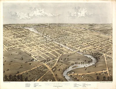
This rare antique map captures WI Waukesha 1857 MAP in remarkable detail. An authentic image from the Library of Congress, it carries the weight of the real historical record.
Library of Congress record: Waukesha, Wis
Choose the framed print, ready to hang the day it arrives, or the unframed print for a frame of your own. It brings character to any room and makes a memorable gift. Free shipping in the lower 48 states. Snapshots of the Past, founded in 2001, has served tens of thousands of customers worldwide.
WI Waukesha 1857 MAP
Order a print
Thank you. Your order went through, and a receipt is on its way by email.
Secure checkout · SSL encryptedPowered by Stripe and PayPal
Free shipping in the lower 48 states. The checkout page shows the picture, size and price before you pay.
This view of Waukesha, the county seat of Waukesha County in southeastern Wisconsin, is drawn from an elevated angle so that the streets, lots, and principal buildings of the town spread out across the sheet. Louis Kurz, a Chicago-trained lithographer, belonged to the generation of artists who made these bird's-eye town views for sale to residents and civic boosters. Maps of this kind were meant to show a community's growth and to present it as a place with rail connections, churches, schools, and busy commercial streets. Viewers today can read the layout of the mid-1850s town and compare it with the modern city.
| Created / published | 1857 |
|---|---|
| Creator | kurz, louis |
| Source | Library of Congress, Panoramic Maps |
| Original scan | 4,928 × 3,450 px · prints to 16 × 12 in at 300 dpi |
| Library of Congress title | Waukesha, Wis |
| Reference | WI-Waukesha-1857 |
More from the PAN MAPS collection
Snapshots of the Past helps heritage brands, museums, historians and storytellers tell stories with history: historic prints, image licensing and historical storytelling drawn from more than 25 years of research and curation.