VA Norfolk 1891 MAP – Historic Map Reproduction

(Each image is professionally and digitally cleaned of artifacts such as color bars and extra borders prior to printing.)
Description
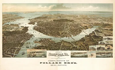
Few images capture their era like this antique map of VA Norfolk 1891 MAP. It is part of the Snapshots of the Past archive, gathered over 25 years of research.
The framed print arrives ready to hang; the unframed option suits custom framing. A conversation-starting piece for home, office, or as a meaningful gift. Free shipping in the lower 48 states. Snapshots of the Past, founded in 2001, has served tens of thousands of customers worldwide.
VA Norfolk 1891 MAP
Order a print
Thank you. Your order went through, and a receipt is on its way by email.
Secure checkout · SSL encryptedPowered by Stripe and PayPal
Free shipping in the lower 48 states. The checkout page shows the picture, size and price before you pay.
This 1891 bird's-eye view shows Norfolk, Virginia, from an oblique height that puts the Elizabeth River waterfront, its wharves and rail lines in the foreground and the city's streets stretching back from the harbor. Norfolk was then a busy port at the edge of Hampton Roads, shipping coal, tobacco and produce, and the railroads that converged there drove its growth in the decades after the Civil War. Panoramic maps like this one were drawn to flatter a town's commercial ambitions, so the detail of docks, warehouses and church spires reflects how residents wanted their city seen. Look closely at the waterfront to see how much of the town's life depended on the water.
| Created / published | 1891 |
|---|---|
| Original scan | 4,559 × 3,368 px · prints to 15 × 11 in at 300 dpi |
| Reference | VA-Norfolk-1891 |
More from the PAN MAPS collection
Snapshots of the Past helps heritage brands, museums, historians and storytellers tell stories with history: historic prints, image licensing and historical storytelling drawn from more than 25 years of research and curation.