Port Jervis, New York, 1920 – Historic Map Reproduction

(Originally scanned by the Library of Congress. Each image is professionally and digitally cleaned of artifacts such as color bars and extra borders prior to printing.)
Description
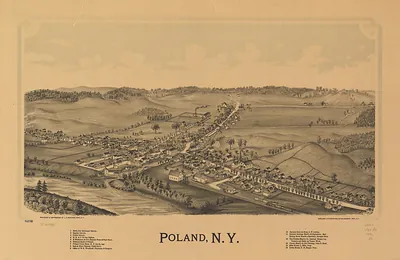
This antique map of Port Jervis, New York, 1920 brings a moment of history to your wall. An authentic image from the Library of Congress, it carries the weight of the real historical record.
Library of Congress record: Aero view of Port Jervis, New York 1920
Choose the framed print, ready to hang the day it arrives, or the unframed print for a frame of your own. It makes a striking addition to a living room, study or office, and a thoughtful gift. Free shipping in the lower 48 states. Since 2001, Snapshots of the Past has shipped historic prints to tens of thousands of customers around the world.
Port Jervis, New York, 1920
Order a print
Thank you. Your order went through, and a receipt is on its way by email.
Secure checkout · SSL encryptedPowered by Stripe and PayPal
Free shipping in the lower 48 states. The checkout page shows the picture, size and price before you pay.
Port Jervis, New York, sat in 1920 where the Neversink River joins the Delaware, close to the points where New York, New Jersey, and Pennsylvania meet. Its economy rested largely on the railroad, since the Erie Railroad's main line and its local shops made the town a major employer and a regular stop for freight and passenger trains. Factories along the river and the surrounding valley added silk and other manufacturing, and the town's streets served a population of shopkeepers, rail workers, and farm families from the hills to the north and west. Civic life centered on the downtown commercial blocks, churches, and schools, and residents would have known Port Jervis first as a railroad town and a gateway to the Delaware valley. The bird's-eye view shows that arrangement of rail yards, river crossings, and dense blocks of houses.
| Created / published | 1920 |
|---|---|
| Creator | hughes & fowler |
| Notes | Bird's-eye view map. |
| Subjects | Panoramic maps--New York |
| Source | Library of Congress, Panoramic Maps |
| Original scan | 10,432 × 7,648 px · prints to 35 × 25 in at 300 dpi |
| Library of Congress title | Aero view of Port Jervis, New York 1920 |
| Reference | NY PortJervis 1920 |
More from the Panoramic Maps collection
Snapshots of the Past helps heritage brands, museums, historians and storytellers tell stories with history: historic prints, image licensing and historical storytelling drawn from more than 25 years of research and curation.