Map of Jefferson County, Ohio – Antique Map Print

(Each image is professionally and digitally cleaned of artifacts such as color bars and extra borders prior to printing.)
Description
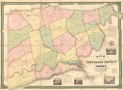
This rare antique map captures Map of Jefferson County, Ohio in remarkable detail. Drawn from the Snapshots of the Past archive, it is an authentic piece of documented history.
Framed, it is ready for the wall; unframed, it is ready for the frame you choose. A fine choice for anyone who loves history, and a gift that gets noticed. Free shipping in the lower 48 states. Snapshots of the Past, founded in 2001, has served tens of thousands of customers worldwide.
Map of Jefferson County, Ohio
Order a print
Thank you. Your order went through, and a receipt is on its way by email.
Secure checkout · SSL encryptedPowered by Stripe and PayPal
Free shipping in the lower 48 states. The checkout page shows the picture, size and price before you pay.
What sets this map apart is its making: the notes credit Jas. Keyly with the actual surveys and Jos. M. Richey with revising and correcting the work before Lee & Marsh of Philadelphia issued it. Jefferson County lies along the Ohio River in eastern Ohio, and its seat, Steubenville, grew up on that river. County maps of the 1850s like this one often served as a practical record of roads, townships and landholdings, which makes them useful to anyone studying how the region was settled.
| Created / published | c. 1856 |
|---|---|
| Medium | map, 139 x 92 cm. |
| Notes | From actual surveys by Jas. Keyly. Revised and corrected by Jos. M. Richey. Lee & Marsh, Philadelphia |
| Original scan | 2,880 × 4,338 px · prints to 10 × 14 in at 300 dpi |
| Reference | Jefferson County Ohio la000643c |
More from the Jefferson collection
Snapshots of the Past helps heritage brands, museums, historians and storytellers tell stories with history: historic prints, image licensing and historical storytelling drawn from more than 25 years of research and curation.