PA Pheoenixville Iron Works – Historic Map Reproduction

(Each image is professionally and digitally cleaned of artifacts such as color bars and extra borders prior to printing.)
Description
This antique map of PA Pheoenixville Iron Works brings a moment of history to your wall. It comes from the Snapshots of the Past collection, curated over 25 years for its historical value.
Choose the framed print, ready to hang the day it arrives, or the unframed print for a frame of your own. It makes a striking addition to a living room, study or office, and a thoughtful gift. Free shipping in the lower 48 states. Since 2001, Snapshots of the Past has shipped historic prints to tens of thousands of customers around the world.
PA Pheoenixville Iron Works
Order a print
Thank you. Your order went through, and a receipt is on its way by email.
Secure checkout · SSL encryptedPowered by Stripe and PayPal
Free shipping in the lower 48 states. The checkout page shows the picture, size and price before you pay.
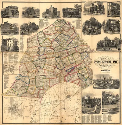
Phoenixville, in Chester County, sits where French Creek meets the Schuylkill River, and by the later nineteenth century its economy rested on the Phoenix Iron Company. The works grew out of earlier forges in the region and rolled iron plate, boiler plate and rails, drawing workers from the surrounding countryside and from abroad. Streets of rowhouses, churches, lodges and fire companies grew up around the mill gates, and daily life followed the shifts at the furnaces and rolling mills. Freight moved along the rail line and the river navigation, linking the town to Philadelphia and to the coal and ore country upriver. Residents knew Phoenixville first as an iron town, its skyline set by stacks and sheds along the water.
| Original scan | 2,943 × 2,217 px · prints to 10 × 7 in at 300 dpi |
|---|---|
| Reference | PA Pheoenixville Iron Works |
More from the Panoramic Maps collection
Snapshots of the Past helps heritage brands, museums, historians and storytellers tell stories with history: historic prints, image licensing and historical storytelling drawn from more than 25 years of research and curation.