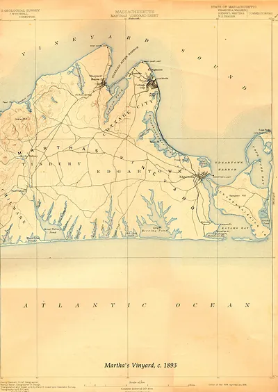
Edgartown-Vinyard Haven-Oak Bluffs USGS 1893-GC, Massachusetts – Vintage Map Wall Art

(Each image is professionally and digitally cleaned of artifacts such as color bars and extra borders prior to printing.)
Description
This rare antique map captures Edgartown-Vinyard Haven-Oak Bluffs USGS 1893-GC, Massachusetts in remarkable detail. It is part of the Snapshots of the Past archive, gathered over 25 years of research.
Order it framed and ready to hang, or unframed to match a frame you already love. A fine choice for anyone who loves history, and a gift that gets noticed. Free shipping in the lower 48 states. Since 2001, Snapshots of the Past has shipped historic prints to tens of thousands of customers around the world.
Edgartown-Vinyard Haven-Oak Bluffs USGS 1893-GC, Massachusetts
Order a print
Thank you. Your order went through, and a receipt is on its way by email.
Secure checkout · SSL encryptedPowered by Stripe and PayPal
Free shipping in the lower 48 states. The checkout page shows the picture, size and price before you pay.
Martha's Vineyard in 1893 was an island of three distinct harbor towns, Edgartown, Vineyard Haven, and Oak Bluffs, each with its own character. Edgartown, the Dukes County seat, still carried the look of its whaling past, though the whaling trade had dwindled after the Civil War and the town now relied more on summer visitors and coastal trade. Vineyard Haven, known as Holmes Hole until 1871, served as the island's main steamboat landing, where ferries from the mainland brought passengers and freight. Oak Bluffs, then called Cottage City, had grown out of the Methodist camp meeting grounds at Wesleyan Grove, and its rows of ornate gingerbread cottages drew summer crowds from Boston and beyond.
| Notes | Bird's-eye view map. |
|---|---|
| Subjects | Panoramic maps--Massachusetts |
| Original scan | 3,150 × 4,445 px · prints to 10 × 15 in at 300 dpi |
| Reference | Edgartown-Vinyard Haven-Oak Bluffs USGS 1893-GC |
More from the Panoramic Maps collection
Snapshots of the Past helps heritage brands, museums, historians and storytellers tell stories with history: historic prints, image licensing and historical storytelling drawn from more than 25 years of research and curation.