KY Louisville 1883 MAP – Historic Map Reproduction

(Originally scanned by the Library of Congress. Each image is professionally and digitally cleaned of artifacts such as color bars and extra borders prior to printing.)
Description
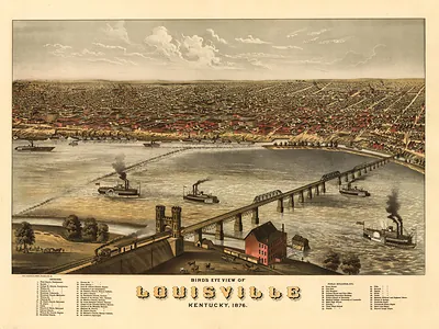
Step back in time with KY Louisville 1883 MAP, an antique map rich in period detail. The original is held by the Library of Congress, so what you hang is a true record of its time.
Library of Congress record: Birds-eye view of Louisville from the river front and Southern Exposition, 1883
Framed, it is ready for the wall; unframed, it is ready for the frame you choose. A fine choice for anyone who loves history, and a gift that gets noticed. Free shipping in the lower 48 states. Snapshots of the Past, founded in 2001, has served tens of thousands of customers worldwide.
KY Louisville 1883 MAP
Order a print
Thank you. Your order went through, and a receipt is on its way by email.
Secure checkout · SSL encryptedPowered by Stripe and PayPal
Free shipping in the lower 48 states. The checkout page shows the picture, size and price before you pay.
Louisville, Kentucky, sits on the southern bank of the Ohio River, and this 1883 bird's-eye view lays the city's streets and buildings out as if seen from a high vantage point. W. F. Clarke drew it during the heyday of panoramic city views, when growing river and rail towns commissioned these pictures to show off their development. By 1883 Louisville was a major river port and rail hub, with tobacco, distilling, and manufacturing shaping its economy. The map is a useful record of how the city filled in along the water and spread outward from its center.
| Created / published | 1883 |
|---|---|
| Creator | clarke, w. f. |
| Source | Library of Congress, Panoramic Maps |
| Original scan | 6,518 × 4,157 px · prints to 22 × 14 in at 300 dpi |
| Library of Congress title | Birds-eye view of Louisville from the river front and Southern Exposition, 1883 |
| Reference | KY-Louisville-1883 |
More from the PAN MAPS collection
Snapshots of the Past helps heritage brands, museums, historians and storytellers tell stories with history: historic prints, image licensing and historical storytelling drawn from more than 25 years of research and curation.