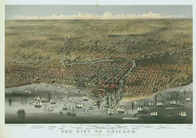
Chicago in 1868, bird's-eye view map – Historic Map Reproduction

(Each image is professionally and digitally cleaned of artifacts such as color bars and extra borders prior to printing.)
Description
Chicago in 1868, bird's-eye view map comes to life in this antique map, reproduced from the original with every detail intact. It is part of the Snapshots of the Past archive, gathered over 25 years of research.
Framed, it is ready for the wall; unframed, it is ready for the frame you choose. Perfect for a home, office, library or classroom wall, and a gift with a story behind it. Free shipping in the lower 48 states. Snapshots of the Past has been bringing history to the wall since 2001, for tens of thousands of customers worldwide.
Chicago in 1868, bird's-eye view map
Order a print
Thank you. Your order went through, and a receipt is on its way by email.
Secure checkout · SSL encryptedPowered by Stripe and PayPal
Free shipping in the lower 48 states. The checkout page shows the picture, size and price before you pay.
Chicago's rapid growth in the 1860s is the story this bird's-eye view of 1868 tells most clearly. Drawn from an elevated oblique angle, the map shows the city's grid of streets, rail lines, and the Chicago River branching through the built-up districts along the lakefront. Bird's-eye views like this were a popular commercial format of the period, produced by lithographic firms that sold them to residents and businesses eager to see their city depicted in detail. The city was still recovering from the Great Fire of 1871's predecessor-era rebuilding and expanding fast, so a map from 1868 captures a metropolis at a moment of confident expansion, just before the devastating fire of 1871 would reshape much of it.
| Created / published | 1868 |
|---|---|
| Original scan | 11,200 × 6,960 px · prints to 37 × 23 in at 300 dpi |
| Reference | IL Chicago 1868 |
More from the Bird's Eye View Maps collection
Snapshots of the Past helps heritage brands, museums, historians and storytellers tell stories with history: historic prints, image licensing and historical storytelling drawn from more than 25 years of research and curation.