Moline, Illinois, 1869 – Vintage Map Wall Art

(Originally scanned by the Library of Congress. Each image is professionally and digitally cleaned of artifacts such as color bars and extra borders prior to printing.)
Description
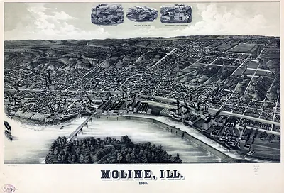
This rare antique map captures Moline, Illinois, 1869 in remarkable detail. The original is held by the Library of Congress, so what you hang is a true record of its time.
Library of Congress record: Bird's eye view of the city of Moline, Rock Island County, Illinois 1869
Order it framed and ready to hang, or unframed to match a frame you already love. A conversation-starting piece for home, office, or as a meaningful gift. Free shipping in the lower 48 states. Snapshots of the Past, founded in 2001, has served tens of thousands of customers worldwide.
Moline, Illinois, 1869
Order a print
Thank you. Your order went through, and a receipt is on its way by email.
Secure checkout · SSL encryptedPowered by Stripe and PayPal
Free shipping in the lower 48 states. The checkout page shows the picture, size and price before you pay.
Moline, Illinois, in 1869 was a fast-growing manufacturing town on the Mississippi River's Rock Island bluffs, shaped by the water power of the Mississippi and the Rock Island Rapids. The Moline Plow Company and the Deere & Company works, whose founder John Deere had moved his steel plow business there from Grand Detour in 1848, anchored the local economy and drew farm machinery makers and skilled workers from across the Midwest. The Rock Island and Peoria railroad lines and the river traffic carried plows, wagons, and grain east and west, and the town's population was climbing as a result. A bird's-eye view from this moment shows a community that was still young, with its factories, churches, and river frontage arranged close together along the water.
| Created / published | 1869 |
|---|---|
| Creator | ruger & stoner, ruger, a., chicago lithographing co |
| Notes | Bird's-eye view map. |
| Subjects | Panoramic maps--Illinois |
| Source | Library of Congress, Panoramic Maps |
| Original scan | 7,280 × 6,256 px · prints to 24 × 21 in at 300 dpi |
| Library of Congress title | Bird's eye view of the city of Moline, Rock Island County, Illinois 1869 |
| Reference | IL-Moline-1869 |
More from the Panoramic Maps collection
Snapshots of the Past helps heritage brands, museums, historians and storytellers tell stories with history: historic prints, image licensing and historical storytelling drawn from more than 25 years of research and curation.