Map of the Yellowstone and Missouri Rivers and their Tributaries – Vintage Map Wall Art

(Each image is professionally and digitally cleaned of artifacts such as color bars and extra borders prior to printing.)
Description
A window into the past: Map of the Yellowstone and Missouri Rivers and their Tributaries, preserved in this antique map. It comes from the Snapshots of the Past collection, curated over 25 years for its historical value.
The framed print arrives ready to hang; the unframed option suits custom framing. A conversation-starting piece for home, office, or as a meaningful gift. Free shipping in the lower 48 states. Since 2001, Snapshots of the Past has shipped historic prints to tens of thousands of customers around the world.
Map of the Yellowstone and Missouri Rivers and their Tributaries
Order a print
Thank you. Your order went through, and a receipt is on its way by email.
Secure checkout · SSL encryptedPowered by Stripe and PayPal
Free shipping in the lower 48 states. The checkout page shows the picture, size and price before you pay.
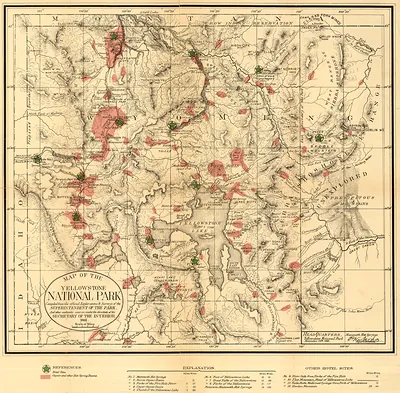
Few early maps of the American West brought together two river systems as ambitiously as this one, which traces the Yellowstone and Missouri and the many streams feeding them across what is now Montana, Wyoming, the Dakotas and beyond. Maps like this were assembled from the reports of explorers, fur traders and army surveyors, who often knew a stream's course far better than its exact position on paper. Its value lies in showing how the Yellowstone country linked to the wider Missouri basin, a connection that shaped trade routes and the military and settler movements that followed in the nineteenth century. Look closely at the tributary names, since many reflect the first European and American travelers who recorded them.
| Original scan | 13,290 × 8,713 px · prints to 44 × 29 in at 300 dpi |
|---|---|
| Reference | ct000847 Map of the Yellowstone and report of F.V. Hayden, M.D. 1859-1860 |
More from the Yellowstone collection
Snapshots of the Past helps heritage brands, museums, historians and storytellers tell stories with history: historic prints, image licensing and historical storytelling drawn from more than 25 years of research and curation.