Old map of Florida, Cuba and the Sinus Mexicanus – Antique Wall Map

(Each image is professionally and digitally cleaned of artifacts such as color bars and extra borders prior to printing.)
Description
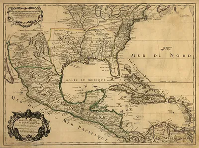
Old map of Florida, Cuba and the Sinus Mexicanus comes to life in this antique map, reproduced from the original with every detail intact. It is part of the Snapshots of the Past archive, gathered over 25 years of research.
Order it framed and ready to hang, or unframed to match a frame you already love. It makes a striking addition to a living room, study or office, and a thoughtful gift. Free shipping in the lower 48 states. Snapshots of the Past has been bringing history to the wall since 2001, for tens of thousands of customers worldwide.
Old map of Florida, Cuba and the Sinus Mexicanus
Order a print
Thank you. Your order went through, and a receipt is on its way by email.
Secure checkout · SSL encryptedPowered by Stripe and PayPal
Free shipping in the lower 48 states. The checkout page shows the picture, size and price before you pay.
The Latin label Sinus Mexicanus, or "Mexican Gulf," names the body of water this map shows between Florida and Mexico. European mapmakers used the term for generations, reflecting Spain's control of the lands along the western shore, before "Gulf of Mexico" became the standard name. Florida and Cuba, both central to Spain's colonial network, appear with the rough outlines and uncertain coastlines typical of the period, when much of the interior was still unexplored by Europeans. The map is a useful record of how that region was understood through a mix of survey, trade routes and secondhand reports.
| Original scan | 6,576 × 5,000 px · prints to 22 × 17 in at 300 dpi |
|---|---|
| Reference | 1600 Spanish |
More from the Across America collection
Snapshots of the Past helps heritage brands, museums, historians and storytellers tell stories with history: historic prints, image licensing and historical storytelling drawn from more than 25 years of research and curation.