Providence, Rhode Island, 1896 – Vintage Map Wall Art

(Originally scanned by the Library of Congress. Each image is professionally and digitally cleaned of artifacts such as color bars and extra borders prior to printing.)
Description
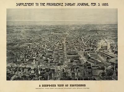
A window into the past: Providence, Rhode Island, 1896, preserved in this antique map. It comes from the collections of the Library of Congress, scanned from the original and carefully restored.
Library of Congress record: View of the city of Providence as seen from the dome of the new State House
The framed print arrives ready to hang; the unframed option suits custom framing. A fine choice for anyone who loves history, and a gift that gets noticed. Free shipping in the lower 48 states. Snapshots of the Past, founded in 2001, has served tens of thousands of customers worldwide.
Providence, Rhode Island, 1896
Order a print
Thank you. Your order went through, and a receipt is on its way by email.
Secure checkout · SSL encryptedPowered by Stripe and PayPal
Free shipping in the lower 48 states. The checkout page shows the picture, size and price before you pay.
In 1896, Providence was still reorganizing its streets around the electric trolley, which by then had replaced horse-drawn cars on many of the main thoroughfares shown on this bird's-eye view. Downtown ran along the Providence River, where wharves and bridges linked the commercial district to the older streets on the east side. Many residents took the cars out to Roger Williams Park, the large public park laid out on the city's southern edge in the 1870s, which drew families on summer weekends. Local newspapers, especially the Providence Journal, which published this map, reported on city council fights over street paving, water supply, and the tax rate, while the city's wealthier families spent the warm months at seaside places along Narragansett Bay.
| Created / published | 1896 |
|---|---|
| Creator | mason, may d., providence journal company |
| Notes | Bird's-eye view map. |
| Subjects | Panoramic maps--Rhode Island |
| Source | Library of Congress, Panoramic Maps |
| Original scan | 1,545 × 1,058 px · prints to 5 × 4 in at 300 dpi |
| Library of Congress title | View of the city of Providence as seen from the dome of the new State House |
| Reference | RI-Providence 1896 |
More from the Panoramic Maps collection
Snapshots of the Past helps heritage brands, museums, historians and storytellers tell stories with history: historic prints, image licensing and historical storytelling drawn from more than 25 years of research and curation.