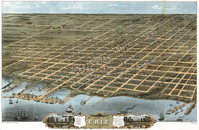
Erie, Pennsylvania, 1909 – Antique Wall Map

(Originally scanned by the Library of Congress. Each image is professionally and digitally cleaned of artifacts such as color bars and extra borders prior to printing.)
Description
Erie, Pennsylvania, 1909 comes to life in this antique map, reproduced from the original with every detail intact. The original is held by the Library of Congress, so what you hang is a true record of its time.
Library of Congress record: Birdseye view of Erie, Penna. 1909
Framed, it is ready for the wall; unframed, it is ready for the frame you choose. It makes a striking addition to a living room, study or office, and a thoughtful gift. Free shipping in the lower 48 states. Snapshots of the Past, founded in 2001, has served tens of thousands of customers worldwide.
Erie, Pennsylvania, 1909
Order a print
Thank you. Your order went through, and a receipt is on its way by email.
Secure checkout · SSL encryptedPowered by Stripe and PayPal
Free shipping in the lower 48 states. The checkout page shows the picture, size and price before you pay.
In 1909 Erie, Pennsylvania, was a lake city of more than 60,000 people, and its factories were reaching beyond the older iron trade. The Hammermill Paper Company, founded in Erie in 1898, had become one of the town's notable employers, and streetcar lines carried workers from the mills to the growing neighborhoods on the rising ground above the bay. Lake steamers still called at the harbor with coal and freight, and the docks sat near the waters where Oliver Hazard Perry's fleet had been built in 1813 before the Battle of Lake Erie. Residents of the day knew the city as a place of shipyards, rail connections and industrial wages, with its naval past never far from the shoreline.
| Created / published | 1909 |
|---|---|
| Creator | lederle, chas |
| Notes | Bird's-eye view map. |
| Subjects | Panoramic maps--Pennsylvania |
| Source | Library of Congress, Panoramic Maps |
| Original scan | 12,511 × 9,184 px · prints to 42 × 31 in at 300 dpi |
| Library of Congress title | Birdseye view of Erie, Penna. 1909 |
| Reference | PA-Erie-1909 |
More from the Panoramic Maps collection
Snapshots of the Past helps heritage brands, museums, historians and storytellers tell stories with history: historic prints, image licensing and historical storytelling drawn from more than 25 years of research and curation.