Boston Harbour, Massachusetts, 1700 – Historic Map Reproduction

(Each image is professionally and digitally cleaned of artifacts such as color bars and extra borders prior to printing.)
Description
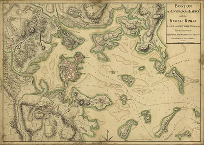
Few images capture their era like this antique map of Boston Harbour, Massachusetts, 1700. It is part of the Snapshots of the Past archive, gathered over 25 years of research.
Framed, it is ready for the wall; unframed, it is ready for the frame you choose. A fine choice for anyone who loves history, and a gift that gets noticed. Free shipping in the lower 48 states. Snapshots of the Past, founded in 2001, has served tens of thousands of customers worldwide.
Boston Harbour, Massachusetts, 1700
Order a print
Thank you. Your order went through, and a receipt is on its way by email.
Secure checkout · SSL encryptedPowered by Stripe and PayPal
Free shipping in the lower 48 states. The checkout page shows the picture, size and price before you pay.
Boston in 1700 was the largest English town in North America north of the Caribbean, a crowded seaport of several thousand people packed onto a narrow peninsula joined to the mainland by a single neck of land. Its wealth came from the water: shipbuilding, the dried cod trade, and voyages carrying lumber and provisions to the West Indies and goods to and from England. Wharves and warehouses lined the waterfront, and merchants, shipwrights, and sailors made up much of the town's working life. Politics ran through the town meeting and a provincial government shaped by the new Massachusetts charter of 1691, while Congregational ministers such as Cotton Mather were among the most influential voices in town. Residents would have known the harbor above all as the gateway through which the colony's trade, news, and people arrived.
| Created / published | 1700 |
|---|---|
| Notes | Bird's-eye view map. |
| Subjects | Panoramic maps--Massachusetts |
| Original scan | 8,052 × 4,500 px · prints to 27 × 15 in at 300 dpi |
| Reference | MA Boston Harbour 1700s |
More from the Panoramic Maps collection
Snapshots of the Past helps heritage brands, museums, historians and storytellers tell stories with history: historic prints, image licensing and historical storytelling drawn from more than 25 years of research and curation.