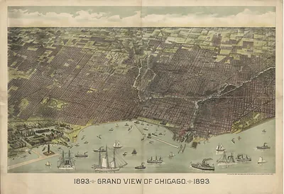
Bird's-Eye View of the World's Columbian Exposition, Chicago, 1893 – Antique Wall Map

(Originally scanned by the Library of Congress. Each image is professionally and digitally cleaned of artifacts such as color bars and extra borders prior to printing.)
Description
Bird's-Eye View of the World's Columbian Exposition, Chicago, 1893 comes to life in this antique map, reproduced from the original with every detail intact. Sourced directly from the Library of Congress, it represents an authentic piece of documented history.
Library of Congress record: Bird's eye view of the World's Columbian Exposition, Chicago, 1893
Framed, it is ready for the wall; unframed, it is ready for the frame you choose. Perfect for a home, office, library or classroom wall, and a gift with a story behind it. Free shipping in the lower 48 states. Snapshots of the Past has been bringing history to the wall since 2001, for tens of thousands of customers worldwide.
Bird's-Eye View of the World's Columbian Exposition, Chicago, 1893
Order a print
Thank you. Your order went through, and a receipt is on its way by email.
Secure checkout · SSL encryptedPowered by Stripe and PayPal
Free shipping in the lower 48 states. The checkout page shows the picture, size and price before you pay.
A bird's-eye panorama of the World's Columbian Exposition, the 1893 fair held in Chicago's Jackson Park, shows the event laid out as a single sweep of white buildings, lagoons, and gardens. Rand McNally and Company published it, and its angled viewpoint lets a reader trace the fair's grand plan at a glance, from the Court of Honor around the Great Basin to the Midway Plaisance running off to the south. The fair was staged to mark the 400th anniversary of Columbus's arrival in the Americas, and its planners, led by Daniel Burnham and Frederick Law Olmsted, gave it the classical style that earned it the nickname "White City." Maps like this one served visitors as both guide and souvenir.
| Created / published | 1893 |
|---|---|
| Creator | rand mcnally and company |
| Source | Library of Congress, Panoramic Maps |
| Original scan | 2,912 × 2,220 px · prints to 10 × 7 in at 300 dpi |
| Library of Congress title | Bird's eye view of the World's Columbian Exposition, Chicago, 1893 |
| Reference | IL-ChicagoExposition-1893 |
More from the PAN MAPS collection
Snapshots of the Past helps heritage brands, museums, historians and storytellers tell stories with history: historic prints, image licensing and historical storytelling drawn from more than 25 years of research and curation.