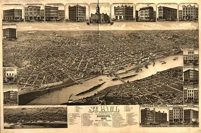
MN St. Paul 1867 MAP – Vintage Map Wall Art

(Originally scanned by the Library of Congress. Each image is professionally and digitally cleaned of artifacts such as color bars and extra borders prior to printing.)
Description
MN St. Paul 1867 MAP comes to life in this antique map, reproduced from the original with every detail intact. The original is held by the Library of Congress, so what you hang is a true record of its time.
Library of Congress record: Saint Paul, Minnesota 1867
The framed print arrives ready to hang; the unframed option suits custom framing. A fine choice for anyone who loves history, and a gift that gets noticed. Free shipping in the lower 48 states. Since 2001, Snapshots of the Past has shipped historic prints to tens of thousands of customers around the world.
MN St. Paul 1867 MAP
Order a print
Thank you. Your order went through, and a receipt is on its way by email.
Secure checkout · SSL encryptedPowered by Stripe and PayPal
Free shipping in the lower 48 states. The checkout page shows the picture, size and price before you pay.
This 1867 bird's-eye panorama shows St. Paul, the Minnesota capital that had grown up on the bluffs above the Mississippi River. Albert Ruger drew the view from a high oblique vantage, and the Chicago Lithographing Company printed it, so the town appears as a continuous streetscape with its river landing, buildings, and surrounding terrain. By the mid-1860s, railroads had reached the city and steamboat traffic still defined its waterfront, which made St. Paul a major commercial hub for the upper Mississippi. Maps like this one were commissioned by local boosters and sold to residents and investors, so they reflect a city's ambitions as much as its actual layout.
| Created / published | 1867 |
|---|---|
| Creator | ruger, a., chicago lithographing co |
| Source | Library of Congress, Panoramic Maps |
| Original scan | 4,368 × 3,416 px · prints to 15 × 11 in at 300 dpi |
| Library of Congress title | Saint Paul, Minnesota 1867 |
| Reference | MN-StPaul-1867 |
More from the PAN MAPS collection
Snapshots of the Past helps heritage brands, museums, historians and storytellers tell stories with history: historic prints, image licensing and historical storytelling drawn from more than 25 years of research and curation.