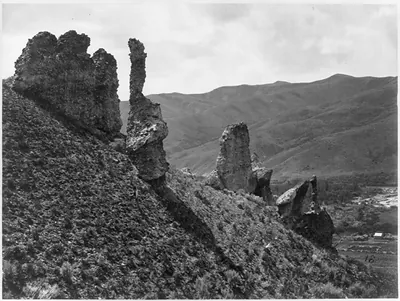
The Pyramid and Domes, Pyramid Lake, Nev. / T.H. O'Sullivan, phot. – Antique Wall Art

(Originally scanned by the Library of Congress. Each image is professionally and digitally cleaned of artifacts such as color bars and extra borders prior to printing.)
Description
Step back in time with The Pyramid and Domes, Pyramid Lake, Nev. / T.H. O'Sullivan, phot., a historic photograph rich in period detail. It comes from the collections of the Library of Congress, scanned from the original and carefully restored.
Order it framed and ready to hang, or unframed to match a frame you already love. It makes a striking addition to a living room, study or office, and a thoughtful gift. Free shipping in the lower 48 states. Since 2001, Snapshots of the Past has shipped historic prints to tens of thousands of customers around the world.
The Pyramid and Domes, Pyramid Lake, Nev. / T.H. O'Sullivan, phot.
Order a print
Thank you. Your order went through, and a receipt is on its way by email.
Secure checkout · SSL encryptedPowered by Stripe and PayPal
Free shipping in the lower 48 states. The checkout page shows the picture, size and price before you pay.
Few views in the survey's Nevada series show a landform as strange as the tufa towers rising from the water at Pyramid Lake, which gave this plate its name. Timothy H. O'Sullivan made the photograph in 1867 while attached to the United States Geological Exploration of the Fortieth Parallel, a federal survey led by geologist Clarence King that mapped the country between the Sierra Nevada and the Rockies. The pale, weathered formations are calcium carbonate deposits that built up where spring water met the alkaline lake, and the image records them as they stood against the basin's dry hills. As Plate 91 of the survey's published set, it shows how the expedition's photographers documented western geology for scientific and public audiences.
| Created / published | [1867] |
|---|---|
| Medium | 1 photographic print : albumen. |
| Genre | Expedition photographs 1860-1870.Albumen prints 1860-1870. |
| Notes | Plate 91 from: Geological exploration of the fortieth parallel / U.S. Army Corps. of Engineers ; Clarence King, geologist in charge. [Washington, D.C., 187-?]. Title from item. |
| Subjects | United States Geological Exploration of the Fortieth Parallel--(1867-1881) Rock formations--Nevada--Pyramid Lake--1860-1870. Lakes & ponds--Nevada--Pyramid Lake--1860-1870. Pyramid Lake (Nev.)--1860-1870. |
| Source | Library of Congress, Prints and Photographs Division |
| Original scan | 1,536 × 1,184 px · prints to 5 × 4 in at 300 dpi |
| Reference | AMZ-SOTP-HPA-114511 |
More from the Historic Print Archive collection
Snapshots of the Past helps heritage brands, museums, historians and storytellers tell stories with history: historic prints, image licensing and historical storytelling drawn from more than 25 years of research and curation.