Dover, New Hampshire, 1877 – Vintage Map Wall Art

(Originally scanned by the Library of Congress. Each image is professionally and digitally cleaned of artifacts such as color bars and extra borders prior to printing.)
Description
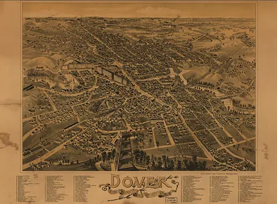
This antique map of Dover, New Hampshire, 1877 brings a moment of history to your wall. The original is held by the Library of Congress, so what you hang is a true record of its time.
Library of Congress record: Bird's eye view of Dover, Strafford Co., New Hampshire 1877
Framed, it is ready for the wall; unframed, it is ready for the frame you choose. A fine choice for anyone who loves history, and a gift that gets noticed. Free shipping in the lower 48 states. Snapshots of the Past has been bringing history to the wall since 2001, for tens of thousands of customers worldwide.
Dover, New Hampshire, 1877
Order a print
Thank you. Your order went through, and a receipt is on its way by email.
Secure checkout · SSL encryptedPowered by Stripe and PayPal
Free shipping in the lower 48 states. The checkout page shows the picture, size and price before you pay.
Dover, New Hampshire, in 1877 was a mill city built around the falls of the Cocheco River, and its settlement dated back to 1623, making it one of the oldest English towns in the state. Its textile works, most prominently the Cocheco Manufacturing Company's mills along the river, employed large numbers of workers, many of them young women from nearby farm families and, increasingly, immigrants from Ireland and French Canada. Railroad lines carried finished cloth out and brought raw cotton and coal in, tying the city to Boston and the coast. Dover had been chartered as a city in 1855, and its civic leaders worked through the 1870s on streets, schools and churches as the population grew around the mills.
| Created / published | 1877 |
|---|---|
| Creator | ruger, a., d. bremner co |
| Notes | Bird's-eye view map. |
| Subjects | Panoramic maps--New Hampshire |
| Source | Library of Congress, Panoramic Maps |
| Original scan | 8,432 × 7,096 px · prints to 28 × 24 in at 300 dpi |
| Library of Congress title | Bird's eye view of Dover, Strafford Co., New Hampshire 1877 |
| Reference | NH-Dover-1877 |
More from the Panoramic Maps collection
Snapshots of the Past helps heritage brands, museums, historians and storytellers tell stories with history: historic prints, image licensing and historical storytelling drawn from more than 25 years of research and curation.