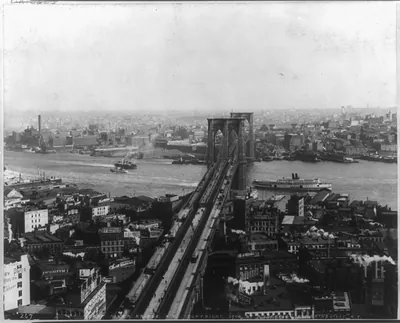
[Aerial view of Navy Yard and East River bridges, Brooklyn] – Historic Photo Reproduction

(Originally scanned by the Library of Congress. Each image is professionally and digitally cleaned of artifacts such as color bars and extra borders prior to printing.)
Description
[Aerial view of Navy Yard and East River bridges, Brooklyn] comes to life in this historic photograph, reproduced from the original with every detail intact. The original is held by the Library of Congress, so what you hang is a true record of its time.
Choose the framed print, ready to hang the day it arrives, or the unframed print for a frame of your own. It brings character to any room and makes a memorable gift. Free shipping in the lower 48 states. Snapshots of the Past, founded in 2001, has served tens of thousands of customers worldwide.
[Aerial view of Navy Yard and East River bridges, Brooklyn]
Order a print
Thank you. Your order went through, and a receipt is on its way by email.
Secure checkout · SSL encryptedPowered by Stripe and PayPal
Free shipping in the lower 48 states. The checkout page shows the picture, size and price before you pay.
An aerial look down on the Brooklyn Navy Yard and the East River bridges places the viewer above one of the city's great working waterfronts. The Navy Yard, established in 1801 on the Wallabout Channel, was by the interwar years a sprawling complex of dry docks, shipbuilding sheds and repair shops, and the adjoining river was crossed by the Brooklyn and Manhattan bridges, which carried heavy traffic between the boroughs. Aerial photography was still a relatively new tool for documenting cities in this period, so the picture offers a rare overhead record of how the shoreline, rail lines and bridge approaches fit together. The exact photographer and circumstances are not recorded here, but the image is valuable for seeing the industrial geography of Brooklyn between the wars.
| Created / published | [between 1920 and 1940] |
|---|---|
| Medium | 1 photographic print. |
| Genre | Aerial photographs 1920-1940.Photographic prints 1920-1940. |
| Subjects | Brooklyn (New York, N.Y.)--1920-1940. |
| Source | Library of Congress, Prints and Photographs Division |
| Original scan | 4,096 × 3,274 px · prints to 14 × 11 in at 300 dpi |
| Reference | AMZ-SOTP-HPA-195042 |
More from the New York City collection
Snapshots of the Past helps heritage brands, museums, historians and storytellers tell stories with history: historic prints, image licensing and historical storytelling drawn from more than 25 years of research and curation.