Philadelphia Exposition, Pennsylvania, 1876 – Antique Map Print

(Originally scanned by the Library of Congress. Each image is professionally and digitally cleaned of artifacts such as color bars and extra borders prior to printing.)
Description
Step back in time with Philadelphia Exposition, Pennsylvania, 1876, an antique map rich in period detail. It comes from the collections of the Library of Congress, scanned from the original and carefully restored.
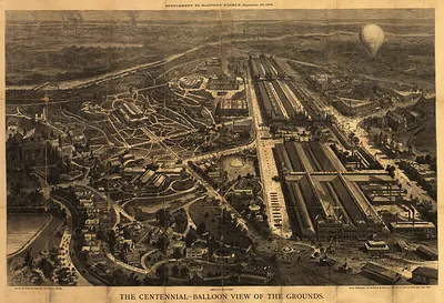
Library of Congress record: Grand bird's-eye view of the Centennial Exhibition grounds and the surrounding country : showing the exact location of every building connected with the great international exposition, drawn in crayon from official topographic surveys made expressly for the Daily Graphic
Choose the framed print, ready to hang the day it arrives, or the unframed print for a frame of your own. Perfect for a home, office, library or classroom wall, and a gift with a story behind it. Free shipping in the lower 48 states. Snapshots of the Past, founded in 2001, has served tens of thousands of customers worldwide.
Philadelphia Exposition, Pennsylvania, 1876
Order a print
Thank you. Your order went through, and a receipt is on its way by email.
Secure checkout · SSL encryptedPowered by Stripe and PayPal
Free shipping in the lower 48 states. The checkout page shows the picture, size and price before you pay.
Philadelphia's Centennial Exhibition opened in Fairmount Park on May 10, 1876, to mark the hundredth anniversary of the Declaration of Independence. The fair came during a hard stretch after the Panic of 1873, and city leaders hoped visiting buyers would place orders with the mills and workshops that made the region's textiles, tools, and machinery. Machinery Hall drew some of the largest crowds, where a huge Corliss steam engine supplied power to machines throughout the building. That summer, Alexander Graham Bell's telephone was also shown to visitors. Millions passed through the gates before the exhibition closed in November, and many Philadelphians remembered it as the season their city stood before the nation and the world.
| Created / published | 1876 |
|---|---|
| Creator | graphic company |
| Notes | Bird's-eye view map. |
| Subjects | Panoramic maps--Pennsylvania |
| Source | Library of Congress, Panoramic Maps |
| Original scan | 4,329 × 3,018 px · prints to 14 × 10 in at 300 dpi |
| Library of Congress title | Grand bird's-eye view of the Centennial Exhibition grounds and the surrounding country : showing the exact location of every building connected with the great international exposition, drawn in crayon from official topographic surveys made expressly for the Daily Graphic |
| Reference | PA-PhiladelphiaExposition-1876 |
More from the Panoramic Maps collection
Snapshots of the Past helps heritage brands, museums, historians and storytellers tell stories with history: historic prints, image licensing and historical storytelling drawn from more than 25 years of research and curation.