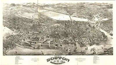
Boston, Massachusetts, 1877 – Antique Map Print

(Originally scanned by the Library of Congress. Each image is professionally and digitally cleaned of artifacts such as color bars and extra borders prior to printing.)
Description
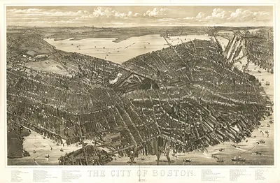
Step back in time with Boston, Massachusetts, 1877, an antique map rich in period detail. Sourced directly from the Library of Congress, it represents an authentic piece of documented history.
Library of Congress record: Boston bird's-eye view from the north
Choose the framed print, ready to hang the day it arrives, or the unframed print for a frame of your own. It brings character to any room and makes a memorable gift. Free shipping in the lower 48 states. Snapshots of the Past, founded in 2001, has served tens of thousands of customers worldwide.
Boston, Massachusetts, 1877
Order a print
Thank you. Your order went through, and a receipt is on its way by email.
Secure checkout · SSL encryptedPowered by Stripe and PayPal
Free shipping in the lower 48 states. The checkout page shows the picture, size and price before you pay.
Boston in 1877 was still recovering from the depression that followed the 1873 panic, and the city's shoe, clothing, and printing shops were feeling slow orders across the country. Trinity Church, designed by H. H. Richardson, was completed that year on the newly filled Back Bay, where brownstone townhouses were climbing up the streets laid out over the former tidal flats. Horse-drawn street railway cars carried residents between the old peninsula and the outlying districts, and the harbor still handled most of the region's coastal and foreign trade. Bostonians in 1877 also followed national politics closely, since Rutherford B. Hayes took the presidency that spring after the disputed election of 1876, a result many in the city saw as the close of Reconstruction.
| Created / published | 1877 |
|---|---|
| Creator | l. prang & co, bachmann, john |
| Notes | Bird's-eye view map. |
| Subjects | Panoramic maps--Massachusetts |
| Source | Library of Congress, Panoramic Maps |
| Original scan | 7,888 × 6,272 px · prints to 26 × 21 in at 300 dpi |
| Library of Congress title | Boston bird's-eye view from the north |
| Reference | MA-Boston-1877 |
More from the Panoramic Maps collection
Snapshots of the Past helps heritage brands, museums, historians and storytellers tell stories with history: historic prints, image licensing and historical storytelling drawn from more than 25 years of research and curation.